SaaS Multi-Hazard Alerting

Climate Analytics & Situational Threat AI

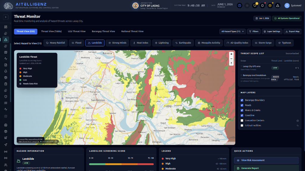
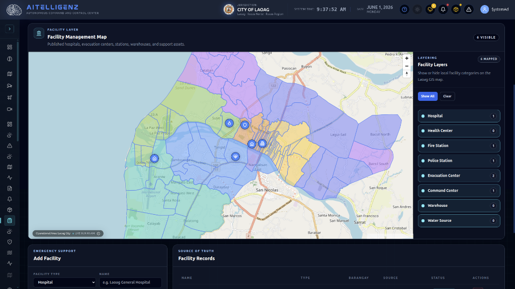
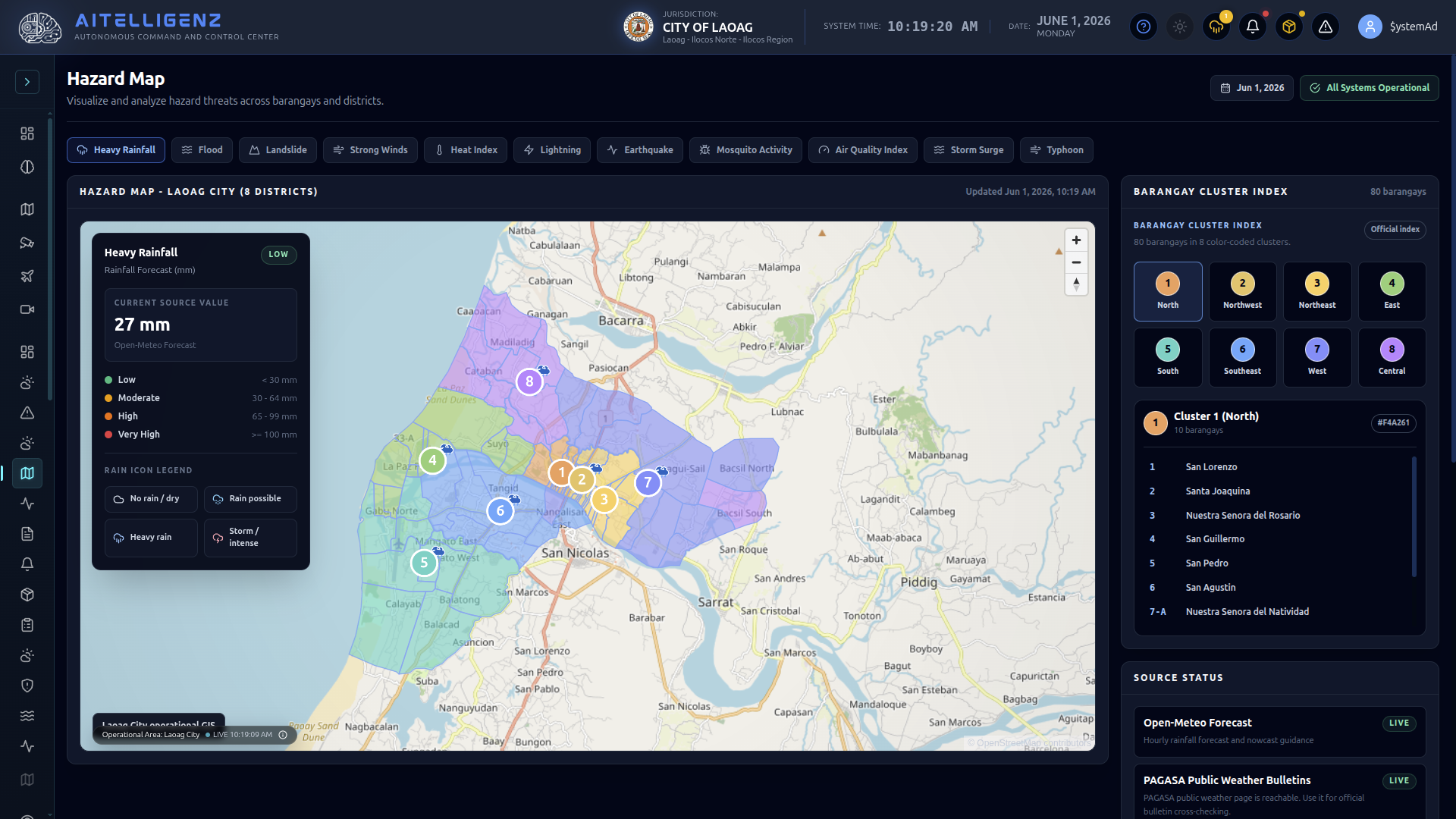
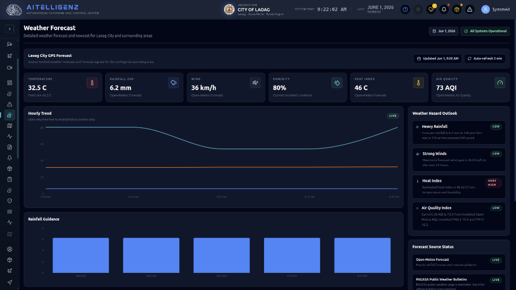
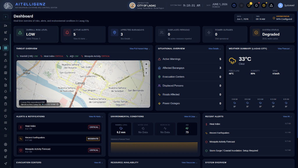
WeatherCast AI bridges the gap between raw meteorological data and municipal action. Tailored for Local Government Units (LGUs), it converts atmospheric telemetry into actionable risk metrics, warning disaster offices before hazards strike.

WeatherCast AI Centralized EOC Dashboard screenshot showing municipal status map and alert indices
● CENTRALIZED EOC ACTIVE
SYSTEM SLA: 98% AVAILABILITY
Heat Index Critical
46°C Feels like limit warning
Air Quality (AQI) Moderate
73 Open-Meteo dataset log
Rainfall (24h) Low Risk
6.2 mm Localized station telemetry
Mosquito Activity High Activity
Critical Climate vectors matched
Environmental Intelligence

Real-Time Situational Awareness

WeatherCast AI computes local risk indexes in real-time, matching climate behavior to immediate safety challenges. Local authorities and residents receive micro-forecast coordinates to safeguard their communities.

  • Climate Risk Metrics: Computes Air Quality Indices, Heat Index curves, and active Mosquito forecasts based on local weather vectors.
  • Local Risk Assessment: Travel advisories and threat ratings mapped down to individual barangays.
Threat monitor dashboard map showing landslide hazard screening scores and barangay zones
Command Center GIS

CDRRMO & Barangay Dashboards

Unify disaster operations under a single, cloud-hosted platform. The system monitors up to **10 natural hazard parameters** in parallel, providing immediate situational updates to the Emergency Operations Center.

  • Multi-Level Threat View: Seamlessly switch between LGU Threat View, Barangay Threat View, and National Threat View.
  • Landslide Screening: Uses rain vectors and soil coefficients to score slope stability hazards automatically.

Environmental Datasets

Aggregating telemetry from satellite feeds, radar, local sensors, and predictive AI models.

Location-Based Forecasts

Real-time rain, wind, temperature, and AQI forecasts & nowcasts calculated at any GPS coordinate within the monitored boundary.

Lightning Detection

Features 95% detection efficiency of cloud-to-ground lightning strikes. Provides 30-minute to 1-hour early detection of developing thunderstorms.

Consolidated Typhoon Tracking

Blends typhoon track models from PAGASA, JTWC, and JMA into a unified geospatial route for predictive storm surge analysis.

Facility management map dashboard showing active hospital, health center, fire, and evacuation zones in Laoag
Geospatial Assets

Facility & Evacuation Mapping

Overlay municipal support facilities directly onto hazard maps. Keep responder agencies updated on available evacuation centers, water points, fire stations, and medical resources across Laoag City's districts.

  • Layer Control Matrix: Dynamic toggle layers for Hospital, Health Center, Fire Station, Police Station, and Evacuation Center counts.
  • Resource Tracking: Live status indicators update capacities and utility availability (e.g. power status, grid outages).
Hazard map screenshot detailing rainfall index parameters and barangay cluster index details
Alert & Broadcast

Localized Alerting & Reports

Trigger automated broadcasts the second thresholds are breached. Deliver micro-targeted notifications down to specific clusters and barangays to speed up evacuation drills.

  • Event-Triggered SMS: Dispatches localized alerts with 500,000 SMS credits included in the base license.
  • Social Auto Post: Connects directly to NDRRMO and Municipal Facebook Pages, auto-generating incident graphics and warnings.
  • Automated Reporting: Daily weather risks and event-triggered Pre-Disaster Risk Assessment (PDRA) reports compiled and emailed to emergency operations managers.
System Core Module

Live Weather Forecast Module

Explore the integrated real-time forecasting panel built into the CDRRMO command console.

Weather Forecast

Detailed weather forecast and nowcast for Laoag City and surrounding areas

All Systems Operational Jun 1, 2026 10:25 AM

Laoag City GPS Forecast

Source-backed weather nowcast and 7-day forecast signals for the operating area.

Updated Jun 1, 10:23 AM Auto-refresh 5 min
Temperature 33.8 °C Feels like 61.5 °C
Rainfall 24h 27 mm Open-Meteo Forecast
Wind 28 km/h Open-Meteo Forecast
Humidity 96% Current modeled condition
Heat Index 61 °C Extreme Caution Level
Air Quality 73 AQI Moderate Index
7-Day Weather Forecast
Today 34°C 25°C 10%
Sat 36°C 26°C 80%
Sun 35°C 26°C 42%
Mon 35°C 25°C 50%
Tue 33°C 25°C 100%
Wed 32°C 25°C 90%
Thu 27°C 25°C 100%
Detailed Hourly Forecast - Today
12 AM 25°C 20%
3 AM 25°C 21%
6 AM 26°C 12%
9 AM 31°C 27%
12 PM 28°C 78%
3 PM 27°C 91%
6 PM 26°C 94%
9 PM 25°C 74%
Rainfall Forecast (Next 7 Days) Total Expected: 119 mm
0 mm
May 29
4 mm
May 30
0 mm
May 31
6 mm
Jun 1
18 mm
Jun 2
27 mm
Jun 3
64 mm
Jun 4

Highest expected rainfall is 64 mm on Thu. Possible impact: localized flooding in low-lying areas.

Severe Weather Outlook Low Risk
Heavy Rainfall
Forecast rainfall is 26.7 mm in 24h and 154.9 mm in 72h at the selected GPS point.
Strong Winds
Maximum forecast wind gust is 28.1 km/h in the next 24 hours.
Heat Index
Estimated heat index is 61.47 °C from temperature and humidity vectors.
Weather Summary
Rainfall 64 mm peak on Thu
Temperature High of 36°C, low 25°C
Wind Gusts up to 48 km/h
Humidity Current trend near 96%

EOC Console Explorer

Click through the core dashboard layers of the Laoag City Multi-Hazard Early Warning installation.

WeatherCast AI Dashboard
Integration Architecture

Geospatial Telemetry & Data Feeds

WeatherCast AI integrates 30+ scientific datasets and real-time observation networks into a unified decision matrix.

Forecast / Nowcast

  • Open-Meteo Global Forecast
  • Open-Meteo Air Quality
  • Open-Meteo GloFAS Discharge
  • Open-Meteo Marine Waves
  • Historical Climate Archive
  • Seasonal Projection Models

Official Cross-Checks

  • PAGASA Weather Bulletins
  • PAGASA Tropical Cyclone Feed
  • PAGASA TC Advisories
  • PAGASA TC Threat Forecast
  • Local Observation feeds
  • Local Observation JSON Store

Water & Landslide

  • DOST-ASTI PhilSensors Rain
  • DOST-ASTI Water Telemetry
  • MGB Flood Susceptibility Layers
  • MGB Landslide Maps
  • LGU Local Rain Gauges
  • River/Drainage Gauge Network

Radar & Severe Weather

  • RainViewer Weather Radar Feed
  • Convective Guidance: CAPE
  • Lifted Index & Weather Code
  • Precipitable Rainfall & Wind
  • AITELLIGENZ Weather-Vector Model

Air Quality Feeds

  • Open-Meteo Air Quality API
  • Sensor.Community PM Stations
  • OpenAQ Global Station Lookup
  • DENR-EMB Municipal Air Stations

Typhoon & Cyclones

  • PAGASA Tropical Cyclone Center
  • Joint Typhoon Warning Center (JTWC)
  • Japan Meteorological Agency (JMA)
  • Consolidated Typhoon Signals

Storm Surge

  • Coastal Inundation Model
  • Configured Storm Surge Providers
  • Typhoon Consensus screening fallbacks

Lightning Networks

  • Commercial Lightning Networks
  • Configured Local Lightning Providers

Earthquake Hazards

  • USGS Earthquake Hazards Program
  • Local PHIVOLCS cross-checks

Internal & Database

  • GIS Intelligence Snapshots
  • Weather Advisory Publisher system
  • Local Observations File store
  • PAGASA Observations File store
  • Persisted Weather Snapshots Database
Licensing & SLA

System Specifications & SLA Matrix

Licensed, supported, and deployed in collaboration with HyperNet business solutions.

Parameter/Service Specifications Status
Scope Covers 8 locations/districts within Laoag City Active Area
App License One (1) Year Cloud / Application SaaS Licenses Covered
SLA Guarantee 98% Service & API availability uptime SLA Standard
Support Crew Dedicated Meteorologist and Data Scientist support team 24/7 Priority
SMS Alerts Credit 500,000 automated event-triggered SMS credits Allocated
Training Curriculum 1-Day Admin Training + 1-Day Env Data Fundamentals Training Included